Friday, November 3, 2017

Bryce Canyon, Utah


Bryce Canyon stands out to me because it is unlike any other National Park. I was here almost 40 years ago, and I was very excited to be seeing it again. We usually like to stay in the National Park campgrounds when possible, even though they don't always have hook-ups for our RV. This time, we chose to get full hook-ups at Ruby's Inn RV Park just outside the park entrance. It was the second week of October and the nighttime temperatures were predicted to drop into the teens, so we needed to be able to run our heater. We didn't want anything to freeze, including us! Definitely a good decision!


On our first day visiting the park, we walked along the rim trail looking down into the canyon.
Most canyons are formed by rivers, but there is no river running through Bryce Canyon. Instead, the limestone rock formations here are formed mostly by weathering and erosion.


Canyon at Sunset

The next day we hiked into the canyon. We chose a combination of the Navajo and the Peek-a-Boo trails for a total of 4.9 miles of ups and downs through the canyon. From below, you have a completely different perspective. It was beautiful.
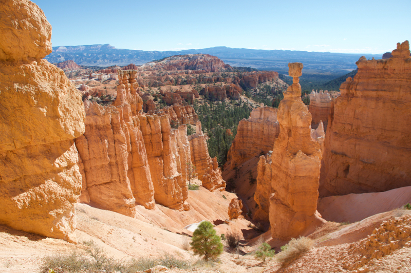
Start of the Navajo trail. Hoodoo Thor's Hammer on right of scene.

Lee on the trail


Scene from the trail


This narrow canyon wall of rock below is called a fin. Frost-wedging (water from snow and ice melt seeping into cracks) eventually enlarges cracks and forms windows. As the windows grow, the tops will collapse leaving a column. Rain will then shape these limestone pillars into hoodoos.

Notice the trail winding through the bottom of the scene

The sun peaking out along the trail

Some people chose another way to explore.

The photo on the right shows the switchbacks that the horses in the photo above were climbing. We followed them up this trail. I was very happy to have my feet firmly planted on the ground!

A few more scenes from the trail because I'm having trouble whittling them down!


At the end of the trail you have to climb back out of the canyon via "Wall Street." Forty years ago, I climbed these switchbacks carrying a 3-year-old on my hip. I think I'd have a little trouble doing that this time!


On our last evening, we watched as the sun was setting on the canyon.


This beautiful park will be hard to top, but we'll be back on the road to keep searching!


The North Rim of the Grand Canyon

From Page, Arizona it was a short drive to the North Rim of the Grand Canyon. I'd been there before but this was a new place for Lynda.

Back in 1992 I did a Backroads cycling trip from Brian Head, UT to Bryce Canyon, then to the North Rim and finishing at Zion National Park. I enjoyed reliving my Backroads trip as we drove the roads I cycled 25 years ago.

We drove up the winding 89A from Marble Canyon, past Vermillion Cliffs to the National Forest campground at Jacob Lake. Jacob Lake is a 40 mile drive along Rt. 67 to the North Rim.
I remembered this road as being lined with trees most of the way but to my surprise there were miles of barren, burned out areas, the result of the 2000 Outlet Fire.

This fire left large open areas providing views of the Vermillion Cliffs.


17 years later the forest is just starting to recover


We were lucky enough to hit the Kaibab Plateau as the Aspens were in full fall color. It was spectacular!


Grand Canyon National Park covers 1.2 million acres and 1904 square miles, is 1 mile deep, and 277 miles long. Several million years ago receding oceans and the newly formed (yet to be named) Colorado River started the erosion that resulted in this "really, really, big hole in the ground".

The North Rim of Grand Canyon National Park and the North Rim Lodge sit above a canyon that runs perpendicular to the Colorado River. This positioning affords a less expansive view of the canyon but it's still spectacular. The overlook nearest the lodge is Bright Angel Point


The Lodge       


A panorama looking SE to S. If you squint real hard you can see the buildings on the south rim...


Of course we took the obligatory "selfie"


After exploring the area around the lodge we took a ride to some other viewpoints along the rim. Point Imperial and Cape Royal.

Views from Point Imperial give a sense of the canyon's vastness and views of the desert beyond.


Angels Window at Cape Royal sticks out into the canyon about 3000 feet from the bottom (!)
When I was here in '92 thunderstorms passing overhead caused a woman's hair to stand on end. Pretty scary!


From the right angle you can catch a glimpse of the Colorado River through the Angels Window.


You can walk on top of the rock above the window and get a better view of the river 1 mile below and several miles away.


I'll end this post with another selfie looking SE toward Vermillion Cliffs and the Painted Desert.


But wait...there's more to come, As We Travel.

Glen Canyon NRA, Lake Powell, Horseshoe Bend, and Antelope Canyon

We arrived in Page, Arizona on the afternoon of October 4th. The campground at Glen Canyon NRA was full, so we stayed at Page Lake Powell Campground. It was close to the road, but conveniently located and adequate for the two nights we planned to stay.

We had come to Page in hopes of seeing Rainbow Bridge National Monument. The only way to see it is by boat on Lake Powell,  but the boat trips to the Bridge were sold out for the next two weeks. Instead, we signed up to take a shorter cruise the next day. Meanwhile, we were excited to discover that there were a few other attractions that we hadn't realized were there. Horseshoe Bend was one of them. Antelope Canyon was another.

Horseshoe Bend is formed by the meandering of the Colorado River. It can be observed from a cliff 1,000' above. There were crowds jockeying for position along the edge of the cliff. I was sure someone would go over the edge. Being terrified of heights and not wanting to get knocked over, I took this photo while lying on my stomach with my head hanging over the edge.


A small section of Lake Powell
Lake Powell is a man-made reservoir formed by the Glen Canyon Dam on the Colorado River. It is one of the largest reservoirs in the United States.


Glen Canyon Dam

Bridge over the dam


Our half-day cruise took us from Wahweap Bay through Navajo and Antelope Canyons and to the Glen Canyon Dam.


The white line is the high-water mark.


 Jet skiing is just one of the many activities on the lake.


Navajo Canyon


    Scenes from Antelope Canyon


After having been through Antelope Canyon from the water, that afternoon we took a guided tour through Lower Antelope Canyon. What a spectacular sight.

Our guide entertained our group while we were waiting for our turn into the canyon.


We wound our way through the narrow slot canyon, snapping photos as we walked, and looking in awe at the beautiful flowing rock walls. The Navajo sandstone walls are somehow transformed into beautiful shades of gold, blue, pink, and purple when photographed in different light.


Off to the North Rim of the Grand Canyon in the morning! Stay tuned.