Friday, July 25, 2014

Turnagain Arm

Just a little way down the Seward Highway from Anchorage is Turnagain Arm, a wide channel that runs 40 miles from Cook Inlet almost to Portage Bay. It is surrounded by steep mountains and forms the northern boundary of the Kenai Peninsula.

We didn't have reservations for the July 4th weekend so we took a chance on getting a spot at the Bird Creek Campground 30 miles south of Anchorage. We were successful and spent July 4-6 "dry camping" in the Bird Creek overflow lot. The overflow lot has the advantage of being above the highway with great views of the arm.


We were greeted by a pair of eagles when we entered the campground. Hello!


The area also has a bike path, the 11 mile Bird to Gird(wood) trail, which is paved and runs alongside the Seward Highway.


See, we did ride our road bikes while in Alaska.


We cruised down to Bird Point where an overlook provided spectacular views.


Turnagain Arm is subject to extreme tides which can reach 6 feet and travel up to 6 mph. We saw pictures of people surfing on the bore tide. The day we saw the bore it was small, about a foot, but impressive nonetheless.


We drove to Girdwood and the Alyeska Ski Area to hike on the Winner Trail. The hike is 5 miles round trip partially on a boardwalk through the boreal forest. It follows Winner Creek and is home to lots of wildlife. Due to the number of people on the trail we didn't see any animals but did find wet moose hoof prints on the boardwalk.


This pic was taken on a heavily reinforced bridge that is used during the winter by sno-cats transporting skiers for out of bounds "cat skiing".


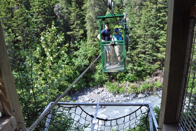
I took a ride across the creek on a "hand tram" which traveled about 200' across and 100' above the water.


As we hiked back to our car from the trailhead I was taken with the beautiful scenery and day.


After a long hike we rewarded ourselves with ice cream at a stand conveniently located at the bottom of the road.


A bit further down Turnagain Arm is a turnoff for Portage Lake/Glacier and the Byron Glacier. The Portage Glacier isn't visible from the visitors center but the lake is full of it's ice.


While in the area we took the short 1 mile hike to Byron Glacier and walked around on snow in a slide area quite a way below the toe of the glacier.


The melting ice and rain carved sculpted paths through the ice.


Again we had to reward ourselves so we had a great pizza at the pizza place right next to where we got ice cream a day before.


Finis!


Thursday, July 24, 2014

Homer, Alaska

From Turnagain Arm, we continued on down to the Kenai Peninsula. We stopped briefly in Soldotna, but that town is all about fishing and we're not, so on we went down to Homer at the tip of the Kenai. It was a beautiful day and our first view of the town was from a hilltop overlook. It was a spectacular view of the mountains surrounding Kachemak Bay with the Homer "Spit" jutting out in the center.


The Homer Spit juts out from the mainland where the actual town is located. The Spit is 5 miles long--the second longest in the world. I don't know what the first is. I need to find that out. The Oceanview RV Park where we stayed was in town, just before you get to the Spit. It was up on a hill, so as the name suggests, it had a wonderful view of the bay. 

We drove to the Spit and took a walking tour. Of course there was a harbor with lots of fishing boats.


It was like being at the Jersey shore on a summer day. On either side of the street there were boardwalks filled with souvenir shops and restaurants, and kiosks offering guided hiking, kayaking, and fishing trips. There are campgrounds on the spit, but we were happy to be where we were so we could get away from the crowds. 

We wanted to do some sea kayaking, so we stopped in at True North Kayak Adventures and signed up for a guided glacier hike/kayaking trip for the next morning. 

Filled with anticipation, we stopped at the Homer Brewing Co. to celebrate our newly made plans. Then we headed back to the trailer to prepare for the next morning's adventure.


We woke up the next morning to gray skies and drizzle. Not great for hiking or kayaking, but we were committed, so off we went, hoping for the best. The shop lent us some boots and rain gear and off we went in a water taxi with our guide, Brad, and two apprentice guides, across the foggy bay to a rocky beach to start our hike.


We started out with our rain gear, but after a short time, the rain stopped and we were able to peel off a layer. We hiked on a trail through a beautiful forest which led to a view of Grewingk Glacier from across a glacial lake filled with icebergs that had broken off the glacier.


Brad took off his shoes and socks and started wading in the ice cold water. He said that it was good for the circulation! I took his word for it! Then the two apprentices got into the act and they all waded in to grab a chunk of glacial ice. I thought they were all nuts!


Lee had his own method of gathering ice.


As we continued the hike through the forest, Brad pointed out and identified various plants and birds for us. We found and tasted all sorts of berries--blue, black current, salmon, and skunk. The latter was true to its name. I wouldn't recommend it!

Nest made from moose hair
Young ptarmigan getting up the courage to fly


After the morning hike, the water taxi picked us up again to take us to our kayak. We paddled around Yukon Island which had a beautiful rocky coastline. The water was emerald green and so clear.


You can tell from my rain jacket and the splotch on the photo that it started to sprinkle again. It got increasingly difficult to take photos while trying to keep the camera dry and keep up my end of the paddling chore.

Despite the rain, we continued to paddle and were able to see some sea otters, a harbor seal, and a few different kinds of birds. A large gathering of common murres and kittiwakes were on the appropriately named Bird Rock.
common murres (top), kittiwakes (bottom)


A group of Harlequin Ducks


Another water taxi ride back to shore and then back to the campground to get dried off and warm up! It would have been nice to have had a sunny day, but it was an adventure nonetheless.

On our last day in Homer, we treated ourselves to a dinner out at The Fresh Catch restaurant. Of course, we both ordered seafood and the restaurant lived up to its name. Everything was delicious!

Now off to Seward and hopes of better weather!


Tuesday, July 8, 2014

Exploring Anchorage

Anchorage is the largest city in Alaska, (Fairbanks is second). About two-thirds of the state's population live in these two cities. Of course, the whole state has fewer than 800,000 people, so it's not like we were in NYC or anything. However, it was the first time in a long time that we actually had some heavy traffic. I had almost forgotten what that was like.

We arrived early in the day, and found a spot in The Golden Nugget RV Park. It was a typical city RV park--a large parking lot, but on the positive side, it was near one of the city's many paved bike trails. The other good news was that it was across the street from Costco, and we were out of peanut butter. We are a Skippy Crunchy family and they only had Jiff, but hey, we were desperate!

We took advantage of a warm day and hopped on our mountain bikes and found the path. There are many miles of interconnected bike trails throughout the city. Our campground was on the outskirts of town, so we started on the Chester Creek Trail through several miles of wooded paths, passing small lakes and parks until we finally reached the Tony Knowles Coastal Trail that runs along the Cook Inlet and brings you closer to downtown.

We found the Visitor's Center, which was a small log cabin with a thatched roof in the middle of downtown.


A view of the street from the Visitor's Center


Lee is posing next to the bust of his childhood hero, Eisenhower. The monument is commemorating Alaska becoming a state in 1959, during Eisenhower's presidency.


From the Coastal Trail, we connected with the Ship Creek Trail and started heading back to the campground. All I can say is thank goodness for Lee's great sense of direction, or we might still be pedaling!

The next day, we visited the Alaska Botanical Garden which has many different native Alaskan plants, perennials, wildflowers, and herbs.

Painted tongue

Foxgloves
Prairie smoke


Poppy


Pansies
Himalayan blue poppy


That evening we went downtown for dinner. We started out at the Crow's Nest at the top of the Hotel Captain Cook for a glass of wine and a beautiful view of the mountains. Then we headed over to Humpy's for seafood and local beer. Humpy's is named for a variety of salmon.


On our last day in Anchorage we decided to hike Flattop Mountain (elev. 3,510'), one of the most popular hikes in the state. You can see from this photo how it gets its name.


The hike started out on a nice wide trail. It was steep, but smooth. This couldn't be too bad! It got steeper, but they put in stairs. 


The view from here was great.


Wait, what happened to the trail? Rock scrambling time! How am I ever going to get down from this?


We made it! Great views of Anchorage, Cook Inlet, and the Alaska Range are in the distance.


Now to figure out how to get down so we didn't have to scramble back over those rocks. So we walked across the top of the ridge to look for an alternate route. Well, Lee looked while I took pictures!


The alternate route was a very steep and slippery slope down to the Powerline Trail below (See that tiny trail in the valley?), but no big boulders to scramble over, so we figured this was a better choice. Lee didn't want me to freeze hanging on to one of the rocks, which I was apt to do, so we forged ahead. It was very slow going.


I'm glad I had my monopod to use as a hiking pole! Lee's photo below shows how steep the mountainside actually was. Yikes!!!


Obviously, we made it down safely and lived to tell the story, but we put our hiking boots away for a couple of days! We left Anchorage the next morning and headed south to Turnagain Arm. More on that in the next post.