Tuesday, June 17, 2014

Richardson Highway to Valdez

On June 11th we left Tok and drove down the Tok Cutoff to Glenallen where we spent the night in the Northern Nights RV park. There's nothing much to speak of in this town, except that it's at the junction of three of Alaska's highways--the Tok Cutoff, the Glen Highway to Anchorage, and the Richardson Highway. It's kind of like Tok in that you have to pass through it to get anywhere. We chose to head south on the Richardson Highway toward Valdez.

The section of road between Glenallen and Valdez was spectacular. I know I keep saying that, but the scenery never gets old. All along the route we paralleled the Wrangell-St. Elias mountain range.


At times, you felt like you could almost reach out and touch the mountains.


The highest point on the highway is called Thompson Pass. Just before you reach the summit, you come to the Worthington Glacier. In 1968, it was designated by the National Park Service as a National Natural Landmark.


This is the terminal end of the glacier. You can't see this portion in the photo above. It's hidden behind a ridge.  To give you some perspective, the red speck at the bottom right is a hiker coming down off the mountain.

We climbed it too! It looks a lot smaller from a distance.

After hiking to the glacier, we continued toward Thompson Pass. It clearly was still winter here!


I was amused by the height of the roadside snow poles that mark the edges of the road for the snow plows. Do you think they get much snow around here? The record is 974.5 inches for a season in 1952-53.

  
When we came down from the summit and got closer to Valdez, the scenery changed dramatically as we passed through Keystone Canyon. It was lush green with the Lowe River running alongside the road.


And waterfalls galore...in particular, this one called Bridal Veil Falls.


This is the remains of the avalanche that cut off the road to Valdez for a couple of weeks in January, 2014. There's also a huge pile of snow on the other side of the road that can't be seen in this photo.


We finally reached our campground, The Valdez Glacier campground, which was a state facility about 3 miles from town. It was a pretty, wooded campground that was much more appealing than the gravel parking lots in town that were called RV parks. We sacrificed all the hook-ups and proximity for the natural setting.

It was a short drive into town where we strolled along the harbor.


Then went to a restaurant called Off the Hook that overlooked the harbor and had a delicious seafood dinner.


The next day, we decided to take a glacier and wildlife cruise to Columbia Glacier in Prince William Sound with Stan Stephens Cruises. The Valdez Spirit was a small boat with about 60 passengers on board.  Lots of room on the decks for viewing and photographing.


As we pulled out of the harbor, I watched a flock of gulls that seemed to be chasing a tow boat. I'm not sure what the attraction was unless there was a school of fish nearby.


This couple from England whom we had seen at the restaurant the night before, happened to be on this cruise too. We had fun spending the day with them and ended up going to The Fat Mermaid together after the cruise for dinner and lots of laughs. One of the best parts of travel is meeting so many fun and interesting people from all over the world. We also met a wonderful German family who are  living in Ohio for a few years and traveling all over the country while they're here in the USA. I wish I had gotten a photo of them.


This is one of many icebergs that had broken off the Columbia Glacier and were floating in the bay. It is the fastest retreating glacier in the world. Warming air temperatures have caused an increase in the amount of ice detaching from the glacier and floating in the ocean.


The glacier once filled this section of the bay. It was originally about 41 miles long. Now it is only about 10 miles long. According to the captain of our ship, it has retreated so quickly that the section of the bay that it had filled is still uncharted water.


In addition to the glacier, we saw an abundance of wildlife....


A humpback whale with its calf. Unfortunately, they didn't stick around for very long.


Lots of sea lions.....


 ....hanging around in all sorts of places,


tufted puffins,


and sea otters, who seemed to be putting on a show for us.


It was a fun day and interesting day. We really enjoyed the time we spent in Valdez. Now off to the next adventure.


Monday, June 16, 2014

Tok - Chicken and back.

Tok (pronounced toke) is where you can turn left onto the Tok Cutoff south to Glennallen or just stay on the Alaska Highway to it's northern terminus at Delta Junction.
Someone asked me "what's in Tok?" To which I answered "nothing". Actually it has a RV repair, a service station where I had the truck tires rotated, a grocery called The Three Bears, a visitors center, a food trailer that serves Thai food and some great bike paths.
We took a ride 9 miles down the Tok Cutoff and saw nothing but an empty highway, but it was nice to be on the bike on a beautiful day.


Going south


Going north


And then there's Chicken. Yep, that's what I said...Chicken. It was originally going to be called "Ptarmigan" but the miners couldn't spell Ptarmigan so it got the name Chicken. Chicken is 68 miles from Tok and 90 miles from Dawson City, YT at the northern end of the Top Of The World Highway.
Chicken is a gold mining "community" that consists of three buildings, two RV parks and many active gold claims.


This is the heartbeat of the thriving metropolis of Chicken. From Left to right: The Chicken Mercantile Emporium, The Chicken Liquor Store, the Chicken Creek Saloon, all linked together and run by (as far as I could tell) one person. The Chicken Creek Cafe is on the right.


We stayed at the Chicken Creek Gold Camp, a working gold claim that was turned into an RV park with a cafe/restaurant/gift shop.
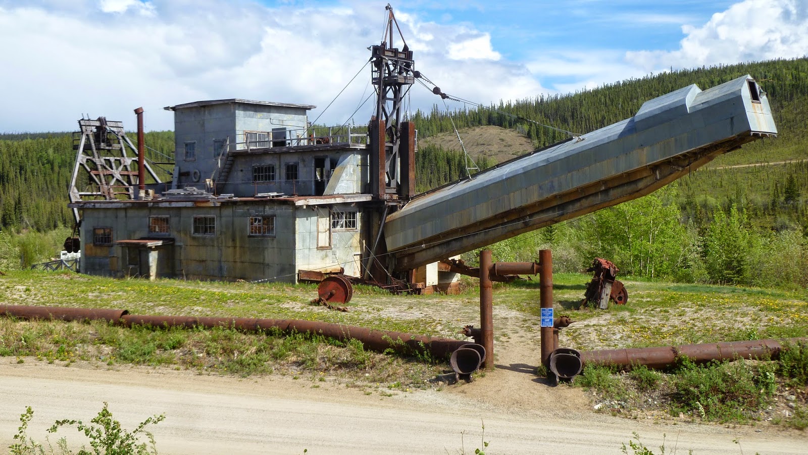
In the background is Pedro, a gold dredge.


Pedro was in use in the early 1900's to mine gold in the Chicken area. The dredge dug it's own moat as it worked its way through an area with gold ore. Steam pipes were inserted in the ground ahead of the dredge to melt the permafrost so Pedro could dig. The rig is huge and was transported in pieces via horse or mule drawn wagons.


At the entrance to the Gold Camp we were greeted by this oversized chicken and signpost directing us to such places as, Barnyard, KY, Roosterberg, Belgium and Fowl Cay, Bahamas.


The big chicken had friends everywhere! 


Every year the Chicken Creek Gold Camp has a music festival called Chickenstock. Unfortunately we weren't going to be around for this sold out event.

Below is a picture of the stage, called the Chicken Coop


Because we were camping on an active gold claim we had to participate in the age old practice of gold panning. After instructions on how to pan for gold we were turned loose on a big pile of paydirt.

First, you start with a pan full of dirt and rocks. Then swirl it in the water so the heavier gold settles to the bottom of the pan.


Then, as you swirl, you sweep out the bigger rocks with your fingers till, voila! You have the small stuff where you can find dust or flakes or "pickers", small nuggets you can pick up with your fingers.


After 3 hours of panning we had enough to...say we panned for gold!


Warning: objects in this picture are (much) smaller than they appear!

Max the Travel Cat, guest blogger

Some people have asked us how Max has adjusted to traveling, so I thought I'd give him a chance to tell you himself. This is an excerpt from Max's journal about trailer life.

I even have my favorite lounger. (Stop taking my picture!)


I have my own room (sort of).


But they always seem to find me!


I have a secret hiding place under the futon.
They spoil me when we travel. I even get to lie on the bed.


My favorite pastime is looking out the window.
But it can get tiring!


I can't do this at home, but like I said, I'm spoiled when we travel.


Sometimes I have to help them with travel plans.

Don't tell me it's time to go in the truck again...Ugh!

I don't know what I'm complaining about. I have the whole back seat to myself....

and all the facilities of home.

Sometimes I have to come up front to complain about the bumps.


Yay, I'm going back inside! And the cycle continues.
The back door is open,  it must be time to get out. 


Wednesday, June 11, 2014

The Last Stretch to the Border

We left Whitehorse, YT on June 4th and headed for the Alaska border. After a brief overnight stop in Haines Junction, YT, we continued on the Alaska Highway as it paralleled the beautiful Kluane (Klu-WAN-ee) Mountain Range. The Kluane Range is the largest non-polar ice field in the world. We could see so many glaciers along the way.


There was one breath-taking scene after another!


After following the mountain range for many miles we came to the south end of Kluane Lake. 


The lake is enormous...45 miles long. We stopped to take a photo and were planning to stop at a visitor's center around the bend when we noticed something in the distance in a field at the edge of the lake. We couldn't make out what it was at first, but then it was clear....it was a grizzly!


Thank goodness for binoculars and telephoto lenses! We were able to get up close without getting up close!


When the grizzly wandered off, we continued on to the Tachel Dahl Visitor's Center which sits at the base of the Tachel Dahl (formerly known as Sheep Mountain). The southern slope of the mountain is the main winter and spring range and lambing area for the Dall sheep. The rams migrate out of the area in May, but females and lambs can be seen from May to early June. They spend the summer on the backside of the slope where it is greener. Then they return to the southern slope in August. Behind the visitor's center a telescope is set up for viewing. The top of the mountain is at 5,000 ft. 

Even with a telephoto lens, they're just white dots on top of the ridge.

Just beyond the visitor's center there was a trail that took us to Soldier's Summit where the original Alaska Canada Military Highway (the Alcan) was officially opened with a ribbon-cutting ceremony in November, 1942. This was the spot where the crews working from the north and south met.  Today the highway is simply called The Alaska Highway.
Road from the South
Road from the North (new road and lake in background)

Plaque commemorating the event


There was a great view of Kluane Lake from Soldier's Summit.


We stopped at a pull-off beside the lake to make some lunch.....one of the advantages of carrying your home with you! I had to take one last look back at the Kluane Mountain Range before continuing down the highway.


We thought we might make it to the border that day, but because of road conditions (that Lee mentioned on an earlier post) we made one last overnight stop in the Yukon in Beaver Creek. The next morning, we made it to the border! 

No, that's not our rig in the background.


One foot in each country!

 After all the photo ops, we passed through Customs with ease. Alaska here we come!